MIAMI – Hurricane Ian remained a Category 3 storm on Tuesday night and was poised to come ashore somewhere along the coast of southwest Florida with Fort Myers in the crosshairs.
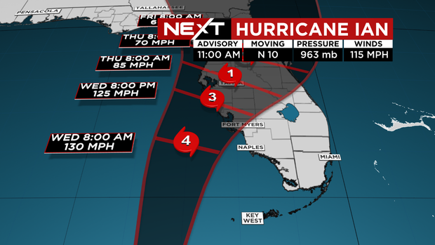
At 11 p.m., Hurricane Ian was moving toward the north-northeast near 10 mph.
On the forecast track, the center of Ian is expected to pass west of the Florida Keys within the next few hours, and approach the west coast of Florida within the hurricane warning area on Wednesday.
The center of Ian is forecast to move over central Florida Wednesday night and Thursday morning and emerge over the western Atlantic by late Thursday.
Maximum sustained winds are near 120 mph with higher gusts.
Ian remains a Category 3 hurricane on the Saffir-Simpson Hurricane Wind Scale.
Strengthening is expected until the hurricane makes landfall.
Hurricane-force winds extend outward up to 40 miles from the center and tropical-storm-force winds extend outward up to 140 miles.
Check out our live updates here.
The storm’s track has shifted, raising the risk of areas south of Tampa, the hurricane center said.
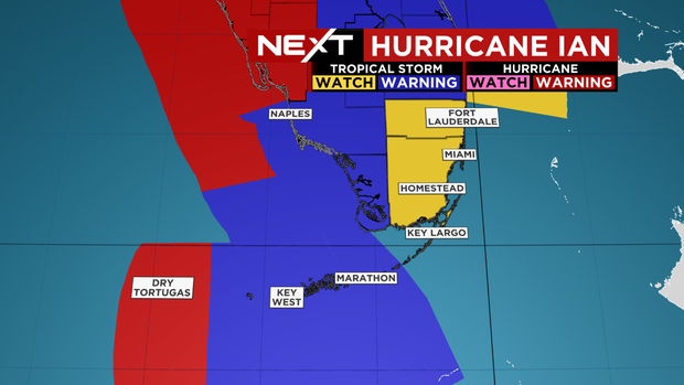
All of Miami-Dade, Broward and the Upper Keys were under a Tropical Storm Watch as the storm moved closer to Florida.
Although a direct hit for South Florida was not expected, school officials with Miami-Dade and Broward decided to cancel classes Wednesday and Thursday.
The storm continued to strengthen as it made its closest approach to the Lower Keys and South Florida.
Heavy rain bands with gusty squalls arrived in the lower Keys on Monday night and will continue spreading north across all of South Florida, including Miami-Dade and Broward, throughout Tuesday and Wednesday.
The Florida Keys and South Florida could see 6 to 8 inches of rain, Central West Florida could get 12 to 16 inches, with some areas seeing up to 24 inches, and the remainder of the Florida Peninsula could get 5 to 10 inches.
NEXT Weather
A few tornadoes formed across South Florida. All products of Hurricane Ian.
The combination of storm surge and the tide will cause normally dry areas near the coast to be flooded by rising waters moving inland from the shoreline.
If the peak surge occurs at the time of high tide, the Florida Keys including the Dry Tortugas could see a surge of 3 to 5 feet, Anclote River to Middle of Longboat Key, including Tampa could see 4-7 feet, the Suwannee River to Anclote River could see 3 to 5 feet, and middle of Long Boat Key to Bonita Beach, including Charlotte Harbor could see 8 to 12 feet.
NEXT Weather
Ian will pass west of the Florida Keys on Tuesday, and approach the west coast of Florida on Wednesday into Thursday.
It is forecast to be a Category 4 hurricane with winds of 140 mph as it passes to our west.
A Hurricane Warning is in effect for the Cuban provinces of Isla de Juventud, Pinar del Rio, and Artemisa, Bonita Beach to the Anclote River, including Tampa Bay, and Dry Tortugas.
A Hurricane Watch is in effect north of Anclote River to the Suwannee River and south of Bonita Beach to Chokoloskee.
A Storm Surge Watch is in effect for the Florida Keys from the Card Sound Bridge westward to Key West, Dry Tortugas, Florida Bay, Aucilla River to Suwanee River, mouth of St. Mary’s River to South Santee River, and south of Marineland to Volusia/Flagler county line.

Share this news on your Fb,Twitter and Whatsapp
Times News Network:Latest News Headlines
Times News Network||Health||New York||USA News||Technology||World News