Chicago weather forecast: Significant snow fall this week, with blizzard conditions Thursday, Friday
CHICAGO (WLS) — A Chicago snow storm this week is forecast to dump several inches of snow on the area on Thursday and Friday ahead of the Christmas holiday, along with very strong winds and dangerous wind chills.
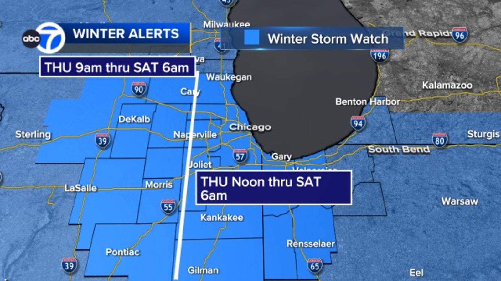
The National Weather Service has issued a Winter Storm Watch for the entire Chicago area and northwest Indiana.
The alert is in effect from 9 a.m. Thursday until Saturday at 6 a.m. for Kane, Kendall, Grundy, Livingston and McHenry, counties. For the rest of the Chicago area, the alert is in effect from noon Thursday until 6 a.m. Saturday, with the alert starting at 3 p.m. for areas in northwest Indiana.
ABC7 Meteorologist Tracy Butler says western suburbs could start seeing snow in the mid-morning hours Thursday, with the city seeing snow during the afternoon and continuing overnight through Friday.
Butler said high winds may also lead to blizzard-like conditions Thursday night into Friday morning. Wind gusts may be up to 50-60 miles-per-hour, reducing visibility and potentially leading to power outages.
What can I do if my flight is canceled, delayed? How to prepare for likely 2022 holiday travel mess
Butler said the storm could bring a potential of four to eight inches of snow by the weekend, with higher amounts possible further east from lake-effect snow.
WATCH | Latest 7-day Chicago weather forecast
ABC7 Meteorologist Larry Mowry said, adding that he expects the Winter Storm Watch will be upgraded to a Winter Storm Warning or Blizzard Warning later in the week.
“The concern will be not only the snow that’s coming down, but the blowing snow, which will reduce visibility,” Mowry said. “And because the winds will be this strong, there is the threat of power outages Thursday night through the day on Friday.”
POLAR PLUNGE | 1st week of winter brings snow and bitterly cold temperatures
Mowry said the heavy snow and high winds will combine to create major travel impacts, with “extremely difficult to impossible travel from Thursday night through the day on Friday.”
Temps will also crash from the teens on Friday to single-digits over the weekend, with the high winds creating dangerously cold conditions. Friday will starts with wind chills as low as -20 and -30, and will stay well below zero through the day, Mowry said.
The forecast for this week has forced many holiday travelers to scramble to change their plans. Most airlines currently have weather waivers in place, which means you can change your flights for free if you have flexible travel plans.
ComEd preparing for potential power outages
ComEd says it is positioning people and equipment to be able to respond quickly to potential power outages.
“We are positioning our people and equipment to respond quickly and safely to any interruptions that result from this snowstorm,” said Terence Donnelly, president and COO of ComEd. “We realize that any interruption is an inconvenience to our customers, especially during the holidays. Avoiding power outages and restoring service quickly is critical. We have strengthened our system over the years to reduce the impacts a storm like this can have on our customers.”
ComEd customers can text OUT to 26633 (COMED) to report an outage and receive restoration information as well as following ComEd on Twitter or on Facebook. Customers can also call 1-800 EDISON1 (1-800-334-7661), or report outages via the website at ComEd.com/report or use the ComEd app.
ComEd warns people never to approach a downed power line and not to approach ComEd crews to ask them about restoration times as they may be working on live electrical equipment.
What are criteria for a blizzard?
In order for a blizzard warning to be issued, the following conditions need to prevail for three hours or longer:
-The storm needs to have sustained wind or frequent gusts to 35 miles-per-hour or greater
=Falling and or blowing snow reducing visibility to less than a quarter mile
Stay tuned to ABC7 Eyewitness News and ABC7Chicago.com for the latest forecast and snowfall amounts as the winter storm approaches.
Cook County Radar DuPage County Radar Will County Radar Lake County Radar (IL) Kane County Radar Northwest Indiana Radar
Copyright © 2022 WLS-TV. All Rights Reserved.
[ad_2]Share this news on your Fb,Twitter and Whatsapp
Times News Network:Latest News Headlines
Times News Network||Health||New York||USA News||Technology||World News