Rare Blizzard Warning Issued for Los Angeles County Mountains. See the SoCal Storm Timeline

A blizzard warning was issued for Los Angeles County mountains as back-to-back cold storms move into Southern California.
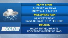
The late February storms will bring heavy snowfall, rain, powerful winds and well below-normal temperatures.
Here’s what to know about the blizzard warning and the timing of this week’s winter storms.
When will the storms arrive in Southern California?
The first storm moves in Wednesday with wind, chilly temperatures, rain and snow continuing into Saturday.
The cold front moved over Southern California Wednesday morning and will produce scattered showers Wednesday evening into Thursday.
Several inches of snow could fall Wednesday on the 5 Freeway in northern Los Angeles County. Scattered rain and snow showers will continue Thursday with the snow levels around 2,500 feet.
Temperatures in most areas will remain in the 50s into Friday.
Rain and snow will intensify Thursday night through early Saturday. Some areas will see rainfall rates of a half-inch to 1 inch per hour.
“We’re going to see some major travel impacts, especially Friday and Saturday, with the potential for some flooding, rockslides and debris flows,” said NBC4 forecaster Belen De Leon.
Los Angeles County coasts and valleys could get a total of 2 to 4 inches of rain. Some foothill areas might receive 4 to 6 inches.
Blizzard warning in Southern California mountains
Snow at unusually low elevations could make for historic snowfall amounts.
A blizzard warning was issued for Los Angeles and Ventura county mountains. The rare warning will be in effect from 4 a.m. Friday to 4 p.m. Saturday with snow totals reaching up to 5 feet at elevations above 4,000 feet by Saturday night.
Some areas could get as much as 7 feet.
Snow levels are expected to drop to 1,500 feet by Wednesday morning. Up to 5 inches of snow might fall by Wednesday night with mountain wind gusts reaching 75 mph.
Snow accumulations of 6 to 12 inches are possible by Saturday night at elevations as low as 2,000 feet. Drivers should expect significant snowfall in most mountain passes.
The Antelope Valley will be under a less severe winter weather advisory from 4 a.m. Wednesday to 4 a.m. Friday. Three to 6 inches of snow are possible in foothill communities and 1 to 3 inches on the valley floor.
What is a blizzard warning?
A blizzard warning generally indicates winter weather conditions that include snow, blowing snow, reduced visibility, strong sustained winds. It is a more severe weather warning that a winter storm warning.
Here’s how the National Weather Service defines a blizzard warning.
The following conditions are occurring or expected within the next 12 to 18 hours.
- Snow and/or blowing snow reducing visibility to 1/4 mile or less for 3 hours or longer
and - Sustained winds of 35 mph or greater or frequent gusts to 35 mph or greater.
Note that there is no temperature requirement that must be met for blizzard conditions.
A less severe winter storm warning is issued when a combination of hazardous winter weather is occurring or imminent.
Significant and hazardous winter weather is defined by the National Weather Service as a combination of the following.
- Five inches or more of snow/sleet within a 12-hour period or 7 inches or more of snow/sleet within a 24-hour period
and/or - Enough ice accumulation to cause damage to trees or powerlines
and/or - A life threatening or damaging combination of snow and/or ice accumulation with wind.
[ad_2]
Share this news on your Fb,Twitter and Whatsapp
Times News Network:Latest News Headlines
Times News Network||Health||New York||USA News||Technology||World News