Millions in Florida are ordered to flee oncoming Hurricane Ian’s path as landfall is expected Wednesday | CNN
Editor’s Note: Affected by the storm? Use CNN’s lite site for low bandwidth.
Are you affected by Hurricane Ian? Text or WhatsApp your stories to CNN +1 332-261-0775.
¿Te ha afectado el huracán Ian? Comparte tu historia por mensaje de texto o por WhatsApp a +1 332-261-0775.
CNN
—
Millions are being urged to evacuate as powerful Hurricane Ian barrels towards Florida, packing the potential for catastrophic flooding and life-threatening storm surge.
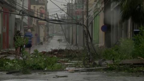
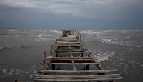
The Category 3 hurricane walloped Cuba after making landfall Tuesday morning, flooding fields, toppling trees and knocking out the island’s power grid.
Ian, now packing powerful 120 mph sustained winds, is expected to slam into the Florida peninsula Wednesday afternoon to evening as a monster Category 3 or Category 4 hurricane, likely somewhere between Sarasota and Port Charlotte, according to the National Hurricane Center.
Devastating wind damage is expected near Ian’s core, the center said.
The hurricane, which was about 90 miles southwest of Naples early Wednesday, began lashing the Florida Keys Tuesday with tropical storm-force winds and power outages.
As Ian moved closer to the state overnight, tropical storm-force winds were reaching the coasts of Southeast and Southwest Florida and major flooding was being reported in Key West due to storm surge.
Water levels were hitting about 2.5 feet above Mean Higher High Water – the third highest level behind 2005’s Hurricane Wilma and 2017’s Hurricane Irma, according to CNN Meteorologist Robert Shackelford.
At least two possible tornadoes were reported in Broward County, including at North Perry Airport, where several planes and hangers were damaged.

A Hurricane Warning is in effect on Florida’s Gulf Coast from Chokoloskee to the Anclote River, including Tampa Bay, and in the Dry Tortugas. A Storm Surge Warning is in effect for multiple coastal areas, including Tampa Bay.
“This will be a statewide event,” Florida Division of Emergency Management Director Kevin Guthrie said.
Schools, supermarkets, theme parks and hospitals across the Sunshine State have announced closures, flights have been canceled, the Navy is moving its ships, the Coast Guard has closed ports, people are boarding up their homes and many are leaving in droves on congested highways.
“The time to evacuate is now,” Guthrie told Floridians Tuesday.
As the storm approaches and winds pick up, officials may close bridges, complicating evacuations for those who don’t leave right away. Gas stations may also temporarily run out of fuel, Gov. Ron DeSantis said.
More than 2.5 million people in Florida have been advised to flee as Ian advances on the state, including 1.75 million people under mandatory evacuation orders, DeSantis said.
In Tampa, police were going door to door in a mandatory evacuation zone Tuesday, making sure residents are ready to flee.
Projections earlier had Hurricane Ian on track to directly hit Tampa Bay, which would have been the first direct hit in 100 years. While the hurricane’s path has shifted south, Tampa Mayor Jane Castor said mandatory evacuations and preparations are continuing.
“No matter where it lands, if it does come in a little south of us, we are not getting out of this unscathed and there is going to be flooding throughout the Tampa Bay area,” Castor said.
The governor warned there will be “catastrophic” flooding and life-threatening storm surge in the Gulf Coast region, with the highest risk in southwest Florida, from Naples to Sarasota.
Photos: Hurricane Ian threatens Florida
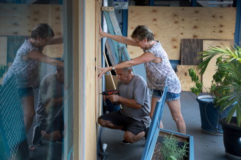
Chris O’Meara/AP
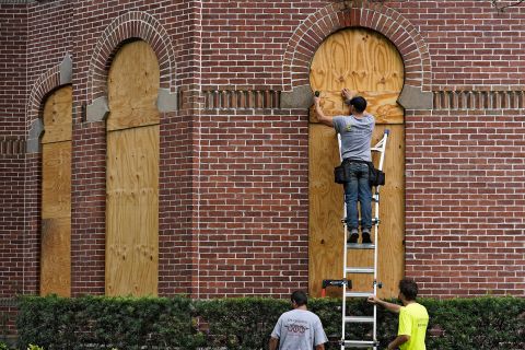
Workers board up the windows on the University of Tampa campus ahead of Hurricane Ian on Tuesday, September 27.
Photos: Hurricane Ian threatens Florida
Yamil Lage/AFP/Getty Images
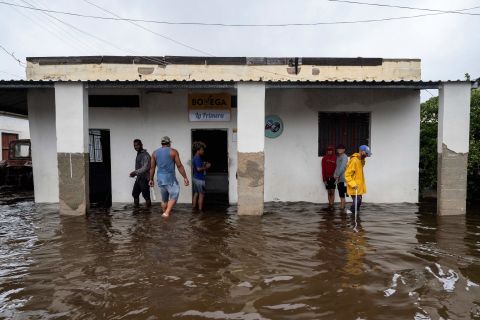
People walk through a flooded street in Batabano, Cuba, on Tuesday.

Photos: Hurricane Ian threatens Florida
Chris O’Meara/AP
Southwest Airlines passengers check in near a sign that shows canceled flights at the Tampa International Airport on Tuesday.
Photos: Hurricane Ian threatens Florida
Rob O’Neal/The Key West Citizen/AP
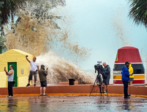
News crews, tourists and local residents take images Tuesday as high waves crash into a seawall in Key West, Florida.

Photos: Hurricane Ian threatens Florida
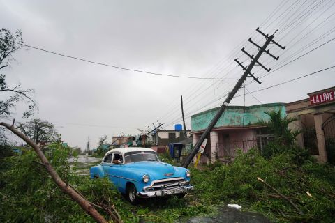
Ramon Espinosa/AP
Maria Llonch retrieves belongings from her home in Pinar del Rio, Cuba, on Tuesday.
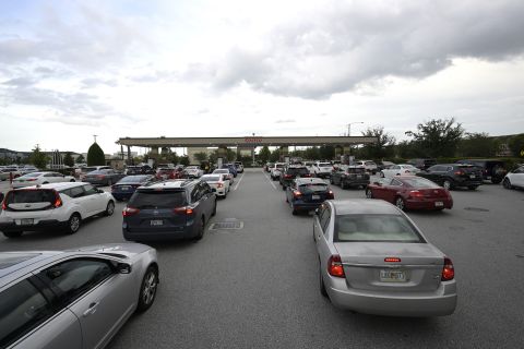
Photos: Hurricane Ian threatens Florida
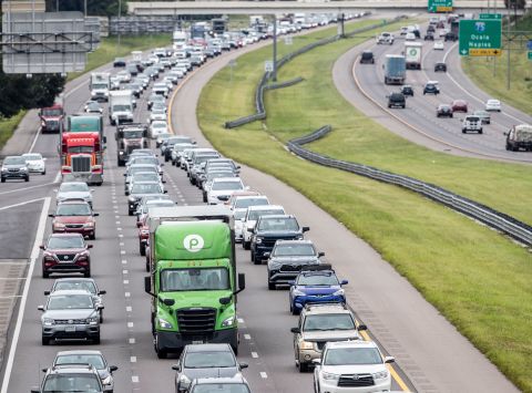
Willie J. Allen Jr./Orlando Sentinel via AP
Traffic builds along Interstate-4 in Tampa, Florida, on Tuesday.
Photos: Hurricane Ian threatens Florida
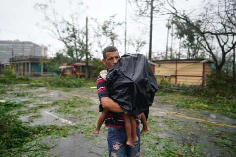
Alexandre Meneghini/Reuters
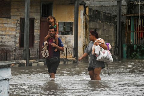
A man carries his children thru rain and debris in Pinar del Rio on Tuesday.
Photos: Hurricane Ian threatens Florida
Alexandre Meneghini/Reuters
People drive through debris in Pinar del Rio, Cuba, on Tuesday.
Photos: Hurricane Ian threatens Florida
Joe Raedle/Getty Images
Frederic Herodet and Mary Herodet board up their Gulf Bistro restaurant in St. Petersburg Beach, Florida, on Tuesday.
Photos: Hurricane Ian threatens Florida
Yamil Lage/AFP/Getty Images
People stand outside a flooded warehouse in Batabano on Tuesday.

Photos: Hurricane Ian threatens Florida
Jim Watson/AFP/Getty Images
NASA’s Artemis I rocket rolls back to the Vehicle Assembly Building at the Kennedy Space Center in Cape Canaveral, Florida, on Tuesday. The launch of the rocket was postponed due to the impending arrival of Hurricane Ian.
 Hurricane Ian reaches the island on Monday, September 26.” class=”gallery-image__dam-img” height=”1145″/>
Photos: Hurricane Ian threatens Florida
Photos: Hurricane Ian threatens Florida
Yamil Lage/AFP/Getty Images
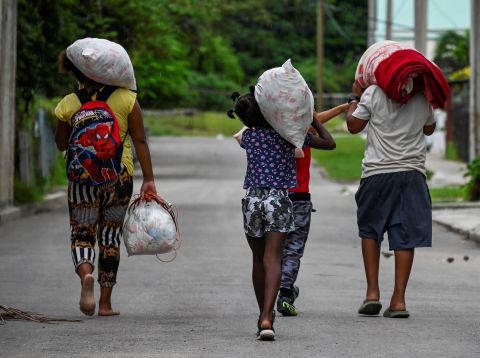
A Cuban family transports personal belongings to a safe place in the Fanguito neighborhood of Havana on Monday.
Photos: Hurricane Ian threatens Florida
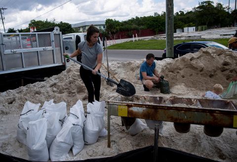
Shannon Stapleton/Reuters
Local residents fill sandbags at Ben T. Davis Beach in Tampa on Monday.
Photos: Hurricane Ian threatens Florida
Phelan M. Ebenhack/AP
People wait in lines to fuel their vehicles at a Costco store Monday in preparation for Ian’s arrival in Orlando, Florida.
Photos: Hurricane Ian threatens Florida
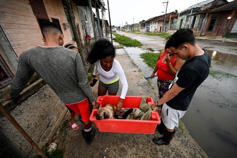
Adalberto Roque/AFP/Getty Images
A family carries a dog to a safe place in Batabano on Monday.
Photos: Hurricane Ian threatens Florida
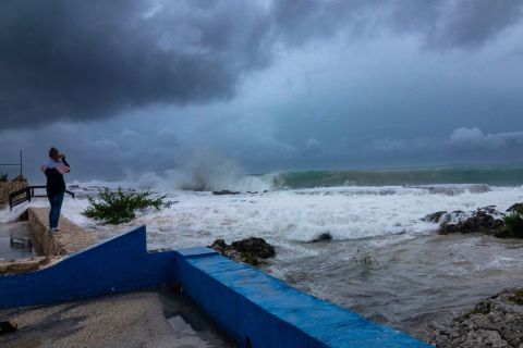
Kevin Morales/AP
A woman takes photos while waves crash against a seawall in George Town, Grand Cayman, on Monday.
Photos: Hurricane Ian threatens Florida
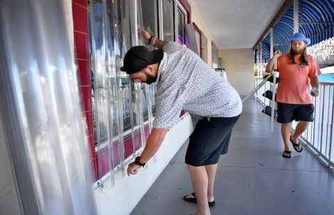
Mike Lang/USA Today Network
Ryan Copenhaver, manager of Siesta T’s in Sarasota, Florida, installs hurricane panels over the store’s windows on Monday.
Photos: Hurricane Ian threatens Florida
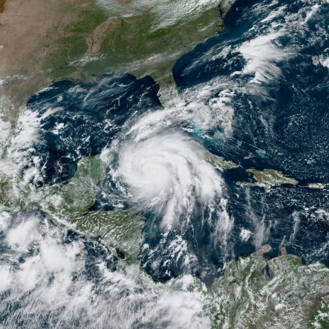
NOAA/NASA
This satellite image, taken Monday at 1 p.m. ET, shows Hurricane Ian near Cuba, right.
Photos: Hurricane Ian threatens Florida
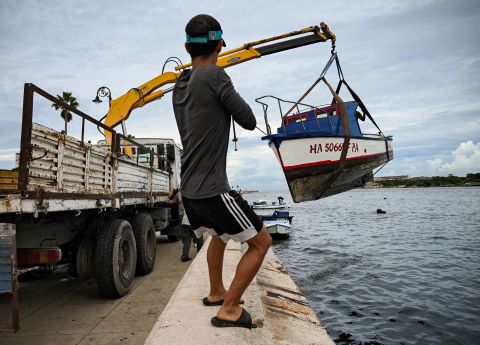
Yamil Lage/AFP/Getty Imagaes
A man helps pull small boats out of Havana Bay in Cuba on Monday.
Photos: Hurricane Ian threatens Florida
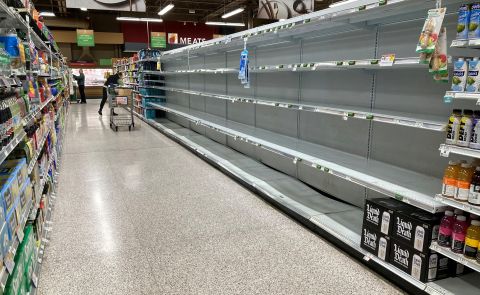
Gregg Newton/AFP via Getty Images
Shelves are empty in a supermarket’s water aisle in Kissimmee, Florida, on Monday.
Photos: Hurricane Ian threatens Florida
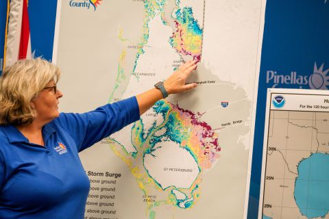
Martha Asencio-Rhine/Tampa Bay Times via ZUMA Press Wire
Cathie Perkins, emergency management director in Pinellas County, Florida, references a map on Monday that indicates where storm surges would impact the county. During a news conference, she urged anyone living in those areas to evacuate.
Photos: Hurricane Ian threatens Florida
Andrew West/USA Today Network
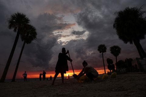
Sarah Peterson fills sandbags in Fort Myers Beach, Florida, on Saturday, September 24.
Photos: Hurricane Ian threatens Florida
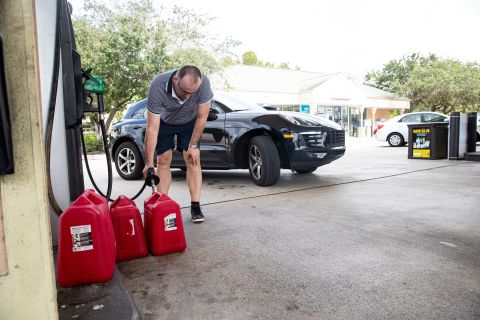
Andrew West/USA Today Network
Besnik Bushati fills gas containers at a gas station in Naples, Florida, on Saturday. The station had only premium gas that morning.
Preparations across the state have been underway for days as residents braced for Ian’s wrath. People were lining up to pick sandbags or flocking to stores to stock up on supplies like water and batteries.
And as the hurricane marched closer, the closures began.
Throughout Florida, 58 school districts have announced closures due to this storm as campuses turned into shelters for those evacuating from their homes.
Disney World is set to close Wednesday and Thursday, and so is Kennedy Space Center’s Visitor Complex.
Hundreds of Publix grocery stores shut their doors Tuesday evening and were expected to remain closed through Thursday.
As millions evacuate, 176 shelters opened statewide and hotels and Airbnbs became available for people leaving evacuation zones, the governor said.
Local governments and state agencies have also been preparing those living in nursing homes and other senior care facilities to evacuate.

Florida has around six million residents over the age of 60, according to the state’s Department of Elder Affairs – nearly 30% of its total population. As of Tuesday, all adult day cares, senior community cafes, and transportation services in evacuation zones are closed, according to the department.
Authorities have also been readying services to fan out and respond to calls for rescue and then, in the aftermath of the hurricane, for recovery and repair efforts.
Nearly 400 ambulances, buses, and support vehicles were responding to areas where the hurricane was expected to make landfall, according to the governor’s office.
DeSantis activated 5,000 Florida National Guard members for Ian’s response operations, and 2,000 more guardsmen from Tennessee, Georgia and North Carolina are also being activated to assist.
Florida officials were also preparing to activate the state’s urban search and rescue teams.
“We have five state teams that are activated with additional five FEMA teams that are in play,” Florida Chief Financial Officer Jimmy Patronis said at a news conference Tuesday night. “We have over 600 resources to bear in addition to these out-of-town teams.”
Strengthening Hurricane Ian is well defined, with a clear eye, National Hurricane Center acting Director Jamie Rhome said in a Tuesday evening update.
“This is not what you want to see in the eastern Gulf of Mexico,” Rhome said.
When the hurricane hits, rising water is expected to move inland from the coastline, bringing life-threatening inundation and flooding to coastal areas.
Millions of people are under a storm surge warning, including the Suwannee River southward to Flamingo, Tampa Bay and the Dry Tortugas.
The area from Longboat Key to Bonita Beach, including Charlotte Harbor, could get up to 12 feet of storm surge, according to the hurricane center.
Warnings are also in place on the state’s east coast from the Flagler-Volusia county line to the mouth of the St. Mary’s River and along the St. Johns River.
After landfall, Ian is expected to crawl across the central part of the state, with damaging winds bringing the threat of tornadoes through Wednesday, according to the National Weather Service.
The slow churn over will “dump an enormous amount of rain on the state of Florida,” DeSantis said.
Ian is expected to dump at least 2-3 months’ worth of rainfall by Friday. Central and Northeast Florida is expected to get 12 to 18 inches of rain, while the Florida Keys and South Florida could get 6 to 8 inches.
Central Florida is expected to see “widespread catastrophic flash, urban, and river flooding” while the southern part of the state should brace for “considerable flash, urban, and river flooding,” the center said.
Under current projections, the hurricane is going to work its way from Southwest Florida, up to the central part of the state, then emerge over the Atlantic Ocean by late Thursday, when it could strengthen again and affect another part of the US.
[ad_2]
Share this news on your Fb,Twitter and Whatsapp
Times News Network:Latest News Headlines
Times News Network||Health||New York||USA News||Technology||World News