
What to Know
- A winter storm is set to arrive in the New York area Thursday afternoon — throwing a wrench into holiday travel plans
- Damaging winds, with gusts up to 50 mph, are expected to grip the tri-state area Thursday afternoon and Friday; heavy rain is expected in and around NYC, while others may see some snow
- Temperatures turn dangerously cold by Friday night, making for icy roads the morning of Christmas Eve; the mercury isn’t expected to reach 30, even, Saturday or Sunday, so they’ll stay that way
A monster winter storm imperiling holiday travel for nearly 200 million across the United States, with airline delays and weather advisories afflicting a broad swath of the country, begins its siege on the New York City area later Thursday. And it’ll stick around for some time.
The local onslaught of heavy snow, ice, flooding and powerful winds associated with the system affecting people from the Plains and Midwest to the East Coast moves in Thursday midday and continues into Saturday.
The blizzard-like conditions many are set to face will make travel virtually impossible for a full day or longer, and intense winds could trigger power outages that, given the frigid weather approaching, could be dangerous if they last.
The main story with this winter storm won’t be blockbuster snow totals locally, but the extensive high wind footprint. Every state east of the Rockies will see gusts of at least 30 mph, with gusts of 50 mph or higher forecast for the I-95 corridor. Those anticipated winds have already led to a number of airlines waiving change and cancellation fees.
Track live weather radar and travel impacts here as the storm hits.
Storm Team 4
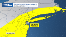
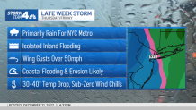
Conditions rapidly deteriorate locally Thursday afternoon, as rain and strong gusts arrive. The rain intensifies overnight and will stay heavy into Friday morning, which could lead to flooding, especially in low-lying and other vulnerable areas. Thunder is possible with some of the heavier rain Thursday night, but widespread severe weather is not anticipated.
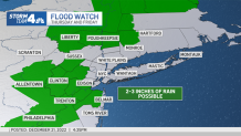
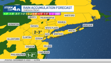
The city could see 2 to 3 inches of rainfall by the time the system moves out.
Coastal flood warnings are in effect for the south shore of Long Island, the Connecticut coastline and the Jersey Shore north of Ocean County. A coastal flood watch has been issued for the city and neighboring counties in New Jersey, as well as Long Island’s north shore. Check the latest weather alerts for your neighborhood here.

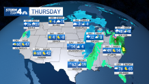
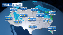
Friday is expected to see far-reaching impacts all day long, across the country and throughout the New York area. Temperatures will rise to unseasonable highs near 60 degrees on Friday, but as the rain ends, dangerous arctic air rushes in, plunging the mercury by about 30 degrees within a matter of hours. That makes flash freezing a major concern.
Wind chills will be at or below zero before dark, and temperatures will be in the teens Friday night. Any wet surfaces, including roadways, could quickly turn to ice by the time many get on the road early Christmas Eve. There’s also a small chance New York City could see a rush-hour flash freeze Friday morning if the winds don’t blow the rain out early. Most impacts are expected later, though.
Airlines have been preparing for the potential weather-related havoc. United Airlines issued an alert for the East Coast.
Anyone slated to travel between Dec. 22 and Dec. 25 won’t be charged change fees or fare differences for United flights, as long as travel is scheduled in the originally ticketed cabin and the ticket was purchased prior to Dec. 18. The rebooking window is Dec. 22 through Dec. 28.
American Airlines also issued a travel alert, while JetBlue says it’ll wave change and cancellation fees for those traveling to or from Chicago, Kansas City, Milwaukee and Minneapolis/St. Paul, given the significant Midwest snow. Southwest Airlines said it canceled 500 of its 4,000 scheduled flights on Thursday and Friday, saying it wanted to maintain safe operations for both passengers and crew.
Alerts may change depending on the weather and airline, so travelers are advised to check with their carriers.
The major winter storm which is expected to disrupt holiday travel could bring record cold to much of the U.S. A climate scientist explains how this cold outbreak is connected to the rapid warming of the Arctic.
Highs and Lows: 3-Day Outlook Across US
Storm Team 4
Storm Team 4
No matter where you’re flying, the weather is going to have a domino effect — so pack your patience. Or change your plans now.
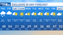
A bit of snow is also possible as the storm pulls away Friday night, mainly in higher elevations, and briefly at that. With temperatures in the city and along the coast in the mid-40s, the white stuff will mainly stay out of the five boroughs.
The Christmas weekend will be sunny, but also breezy and bitterly cold, possibly the coldest in decades. Temperatures aren’t expected to reach the freezing mark — even as a high — until next Tuesday, at the earliest.
We should get back above that mark to close out the year, with the long-range forecast predicting highs topping 40 degrees for Dec. 29. It’s still too early to know the New Year’s Eve forecast, and much could change with this week’s storm too as it develops. Stay with Storm Team 4 for updates.
[ad_2]
Share this news on your Fb,Twitter and Whatsapp
Times News Network:Latest News Headlines
Times News Network||Health||New York||USA News||Technology||World News