
What to Know
- A powerful winter storm triggering weather alerts across the U.S. triggered major coastal flooding and downed trees across Long Island, Queens and parts of the Jersey Shore; travel is chaotic
- Tri-state power outages peaked around 125,000 Friday morning but were drastically reduced by early afternoon; frigid temps could make more problems, though, so stay weather aware for weekend
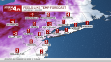
- Wind chill warnings are in effect for much of central and northwestern New Jersey, with the outside air feeling like -10 to -20 — which could cause frostbite on exposed skin in as little as 30 minutes
The arctic blast has arrived.
Wind chills dropped to near or below zero for most of us overnight and will stay in the single digits much of Saturday. Anyone wishing for a little Christmas relief won’t find any. The downright dangerous wind chills gripping the tri-state will hang around through the end of the weekend, at least.
Before any signs of warm-up reach us, temps will continue to hover around zero for the first half of the weekend.
Black ice is a major concern for travelers or anyone stepping out the front door. Bridges and overpasses tend to freeze first, and black ice is nearly impossible to see. If the road looks wet or like there is a puddle, assume it is ice.
Wind chill warnings are in effect for much of central and northwestern New Jersey, with the outside air feeling as low as -10 to -20 — which could cause frostbite on exposed skin in as little as 30 minutes. Check the latest weather alerts for your neighborhood here.
The monstrous winter storm has jeopardized the holiday for countless homebound travelers. Hundreds of flight at NYC-area airports were canceled Friday, and a couple hundred more had been impacted Saturday as well.
Gov. Kathy Hochul declared a state of emergency for the Big Apple ahead of the storm, encouraging holiday travelers to either move up their plans or delay them, with the multi-faceted storm generating wind gusts near 60 mph and downpours that inundated coastal areas with up to 3 feet of water.
Reports of multiple cars stranded during high tide in Long Island’s Freeport came in early Friday. No injuries were immediately reported there. In the city, crews were prioritizing parts of southern Queens that were hard hit by high tide in the morning. Residual flooding will be addressed as tides recede. The one Friday night isn’t expected to be as bad.
The winter siege began Thursday, and while other parts of the country saw blizzard-like conditions, it didn’t feel like much of a winter storm locally until Friday evening, as temperatures plunged and wind chills turned sub-zero. It did feel like a thunderstorm at times, with weather alerts up for parts of the city and subway and coastal flooding reported.
Get real-time transit updates here as the powerful storm continues.
Coastal neighborhoods were inundated by floods and the race is on to dry out as frigid temperatures move in. We’ve got team coverage from New York, New Jersey and Connecticut and the latest on the national picture.
The trick to walking safely on ice is to walk like a penguin. Infographic by Tablet Infographics
What’s Next
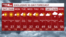
The Christmas weekend will be sunny, but also breezy and bitterly cold, possibly the coldest in decades. Temperatures aren’t expected to reach the freezing mark — even as a high — until next Tuesday, at the earliest. We’ll be able to get out of “dangerous” cold territory by Monday afternoon, though.
Temperatures will be slow to moderate early next week so it stays cold. By late week we’ll be near average, then, plot twist: it looks like the 50s return for New Year’s Eve and New Year’s Day.
The Department of Sanitation will be salting the streets to ward off black ice — and for the first time, the city will salt bike lanes as well. Officials are asking travelers to stay off the roads if at all possible and take mass transit instead.
We should get back above that mark to close out the year, with the long-range forecast predicting highs topping 50 degrees for New Year’s Eve and New Year’s Day. Stay with Storm Team 4 for updates.
[ad_2]
Share this news on your Fb,Twitter and Whatsapp
Times News Network:Latest News Headlines
Times News Network||Health||New York||USA News||Technology||World News