
What to Know
- We’ve got a chilly but quiet few days weather-wise, then the next storm chance arrives late this week
- Expect strong winds, at times heavy rain and plunging temperatures Thursday and Friday, making travel a nightmare for those looking to get out of the city ahead of the holiday due to the icy conditions
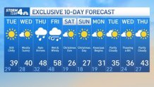
- It’ll be bitterly cold this weekend, with highs not even expected to reach 30 degrees either day
Enjoy the sun these next few days. You’re going to miss it by the end of the week.
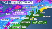
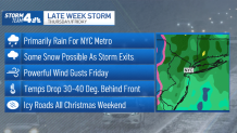
Quiet, chilly weather is on tap for the tri-state area through Wednesday before the next big storm hits the region Thursday afternoon. The New York City area should see primarily rain, as has been the case with the two recent coastal storms that dumped snow far north and west of the five boroughs. Wind and plunging temps are concerns, though.
Gusts could hit 60 mph by Friday morning, along with buckets of rain for the tri-state. Much further to the north and west will see snow, but with temperatures locally in the mid 40s, the white stuff will stay far away from the city (for the most part). All that driving wind and rain could lead to power outages throughout the region.
Then the cold comes.
Temperatures are expected to drop 30-40 degrees in a matter of hours, between Friday afternoon and Saturday morning. That could bring a bit of snow to the city on the back end of the system as a front sweeps through, but no accumulation is expected. The cold blast could also trigger flash-freezing, making for icy travel later Friday and especially on Saturday.
Drivers and pedestrians alike are advised to take extra caution with weekend temps below 30 both days, as the wet roads and sidewalks from Thursday and Friday could become slippery ice rinks on Christmas Eve morning, if not properly treated. While the wet weather will have cleared out, travel that morning looks to be dicey due to the potential for icy roads and possibly power outages from the wind, rain and ice that forms.
Anyone looking to fly out of the tri-state ahead of the holiday should anticipate facing airport delays starting Thursday evening, and it may be worth seeing if it’s possible to fly out before then. Not only with the wind and rain locally create problems, but areas in the midwest will be getting slammed with snow. Even if you’re heading elsewhere in the country, the weather is going to have a domino effect for all flights, so be sure to keep an eye on your air carrier to see how the weather impacts your flight.
It’ll stay freezing through Christmas and a bit beyond, but there’s a good chance we get back above freezing to close out the year, with the long-range forecast predicting highs topping 40 degrees for Dec. 29. It’s still too early to know the New Year’s Eve forecast, and much could change with this week’s storm too as it develops. Stay with Storm Team 4 for updates.
[ad_2]
Share this news on your Fb,Twitter and Whatsapp
Times News Network:Latest News Headlines
Times News Network||Health||New York||USA News||Technology||World News