
Did you get a chance to enjoy the unseasonably warm temperatures Thursday? Well, we’re about to be reminded that it is still actually the middle of winter, although the big chill will be a short-lived one.
Some areas shattered record highs Thursday: Islip reached 71 (!!) degrees in the afternoon, which is far above the previous high of 59 degrees, set back in 2018. Both NYC airports and Bridgeport, Connecticut, set or tied record highs as well.
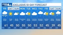
While temperatures aren’t expected to drop immediately, it’s not like we’ll be able to enjoy the warm weather. Friday may yet again bring highs into the 60s, but don’t let that fool you: it’s gonna be a cruddy day, weather-wise. The twist is that the high for the day will happen before noon.
We’ll start in the low 60s, but the rain comes back Friday morning and could stick around into the afternoon. There could even be a rumble of thunder. Paired with gusty winds reaching 30-40 mph and falling temps as a cold front moves into the region, it makes for an unpleasant experience outdoors.
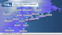
Then it gets cold — not the coldest weather we’ve seen this season, but still frigid. Wind chills are expected to dip into the teens by late Friday night and into Saturday morning. The day will start out below freezing for many, but sunny skies will warm the area up to the mid 40s in the afternoon.
We return to 50-degree weather on Sunday, which will stick around for President’s Day and through much of next week. There’s a chance for showers on Thursday, and that will be followed by cooler temperatures for the final weekend of February.
Share this news on your Fb,Twitter and Whatsapp
Times News Network:Latest News Headlines
Times News Network||Health||New York||USA News||Technology||World News