
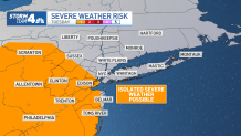
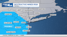
Gusty thunderstorms are possible for parts of the tri-state area later Tuesday, potentially impacting the evening commute with downpours, hail and icy precipitation — and that’s just the appetizer.
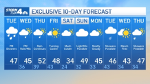
Mother Nature is serving up a potpourri of sorts, one featuring a mix of chilly rain, sleet and snow over the next few days. Tuesday’s morning rains tapered off shortly after sunrise, but another round of rain is expected in the afternoon and early rush. That line of storms could bring thunder, hail, and graupel (weather-speak for hail-ish, icy precipitation pellets), though destructive winds are considered the greater threat at this point.
Check the latest severe weather alerts for your neighborhood here. The system clears out, paving the way for dry, clear and cold weather through Wednesday morning. The next storm moves in Wednesday afternoon.
Storm Team 4
That late-afternoon system could bring a brief period of snow, with discernible flakes possibly even in snow-deprived New York City, by the late afternoon and early evening commute Wednesday. Then we get a lull, followed by a cold rain for most. Those mainly north of the New Jersey-New York-Connecticut border should see freezing rain and sleet.
Driving conditions in those zones — which cover spots like Ulster, Dutchess, Sullivan and Pike counties — will be less than ideal through Thursday’s early morning commute. Temperatures rise above freezing from late morning on, which will help melt any lingering ice.
Storm Team 4
We’re looking at cooling temps Friday — down to about 48 from above 50 on Thursday — and more cooling Saturday. Wind chills could be in the teens to start the weekend once again, and it’ll stay breezy and chilly through the day.
By Sunday, we’re back to above-average temperatures. We’re tracking yet another storm system that could hit in a week, but at this point, it’s too hard to predict how it could impact the tri-state area. For now, expect rain and stay with Storm Team 4 for all the latest weather developments.
Storm Team 4
The latest weather expectations come after some local spots shattered record highs Thursday. Islip reached 71 (!!) degrees in the afternoon, which is far above the previous high of 59 degrees, set back in 2018. Both NYC airports and Bridgeport, Connecticut, set or tied record highs as well.
Track any approaching precipitation using our interactive radar below.
[ad_2]
Share this news on your Fb,Twitter and Whatsapp
Times News Network:Latest News Headlines
Times News Network||Health||New York||USA News||Technology||World News