
With only a few official weeks of winter left, an approaching storm could finally bring New York City some accumulating snowfall (if anyone’s still interested), while other parts of the tri-state area, including much of the Hudson Valley and northern New Jersey, could see more than a half-foot associated with this system.
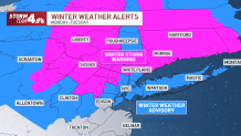
Forecast predictions shifted slightly late into the weekend, now showing greater potential for more snow in the metro and surrounding area than expected last week. At this point, New York City and Long Island, which are under a winter weather advisory, could see 3 to 5 inches of snow, though sleet and rain will likely mix in at times.
Borderline temperatures in the city will likely impact snow totals, but snow may fall steadily enough at night to overcome above-freezing temperatures and actually yield some ruler-worthy (or sort of, anyway) totals for the five boroughs. Up to 8 inches are possible for parts of New Jersey — and a winter storm warning has been issued for areas of Passaic and Morris counties, where heavier bands of snow are expected. Check the latest weather alerts here.

Storm Team 4
Winter Storm Timeline and Expectations
Monday morning stays quiet, with the storm still to our west and moving closer.
MONDAY AFTERNOON
- NYC: Snow arrives early evening; temps stay above freezing. Snow sticks to grass, but roads stay wet; onshore wind begins to increase; expect a messy evening commute
- Lower Hudson Valley (Westchester, Putnam, Rockland and Orange counties): Snow starts to fall in the early evening; temperatures are near-freezing and slushy accumulation is likely; messy evening commute
- Upper Hudson Valley (Dutchess, Ulster counties): Snow arrives in the evening; very light accumulation possible by 6 p.m. or 7 p.m.; messy evening commute
MONDAY NIGHT/OVERNIGHT (11 P.M.)
- NYC: Snow continues; slushy accumulations possible; gusty east to southeast wind; minor coastal flooding possible after midnight with approaching high tide (2 a.m.)
- Lower Hudson Valley (Westchester, Putnam, Rockland and Orange counties): Light snow accumulations as temperatures trend down, close to freezing
- Upper Hudson Valley (Dutchess, Ulster counties): Snow continues to accumulate, a few inches possible by 11 p.m.; temperatures at or below freezing
TUESDAY MORNING
- NYC: Rain/snow mix; temperatures still above freezing; gusty northeast wind; messy morning commute
- Lower Hudson Valley (Westchester, Putnam, Rockland and Orange counties): Steady snow starts to taper off; 3 to 5 inches look likely; messy morning commute
- Upper Hudson Valley (Dutchess, Ulster counties): Snow pulls away by 7 a.m.; 5 to 8 inches of accumulation possible, though subject to change; messy morning commute
Stay with Storm Team 4 for all the latest weather developments. Sign up for our newsletters here.
Track any approaching precipitation using our interactive radar below.
[ad_2]
Share this news on your Fb,Twitter and Whatsapp
Times News Network:Latest News Headlines
Times News Network||Health||New York||USA News||Technology||World News