The highest risk of severe storms in North Texas will be in the afternoon and into the evening.
DALLAS — We’ll be tracking these strong to severe storms in North Texas until they leave the area Thursday night.
Stick with WFAA and the WFAA app for continuing coverage throughout Thursday, including updates from chief meteorologist Pete Delkus at 5 p.m., 6 p.m., and 10 p.m.
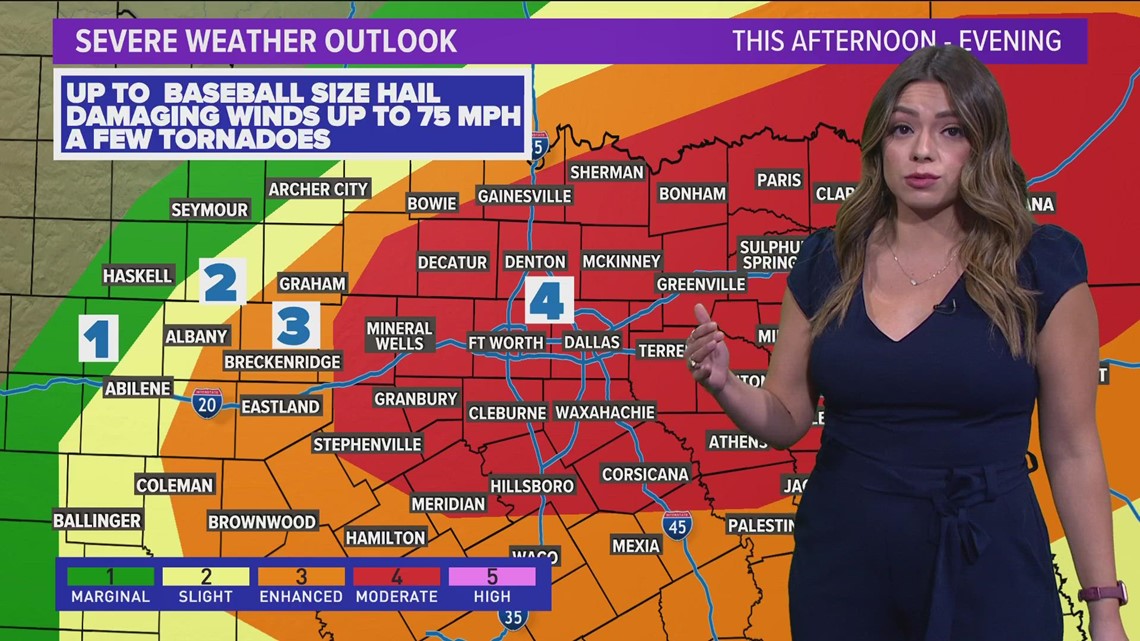
Thursday is expected to be an active weather day across North Texas, with severe thunderstorms and a potential for tornadoes.
Shortly after 10:30 a.m., the National Weather Service expanded the Level 4 out of 5 “moderate” risk level to include most of North Texas, increasing the threat of strong storms throughout the day.
A Level 4 storm threat can include the likelihood of widespread severe storms that can bring up to baseball-size hail, wind gusts up to 75 mph and tornadoes.
Here’s the current outlook:
For reference, level 1s and 2s are very common here in North Texas during severe weather season. The level 3 risk is certainly not unheard of, but less common. Level 4 risks are uncommon, and we may only see one or two (if any) in a given year. Level 5s, which are NOT in the forecast, are very rare. We have a lot more information on the risk categories here.
LIVE RADAR
Thursday Forecast
The day will start out cloudy and muggy with some scattered showers or storms possible. The severe threat will be very low Thursday morning, but it is not impossible to see some rain here or there. Central Texas could see more isolated strong to severe storms during this time.
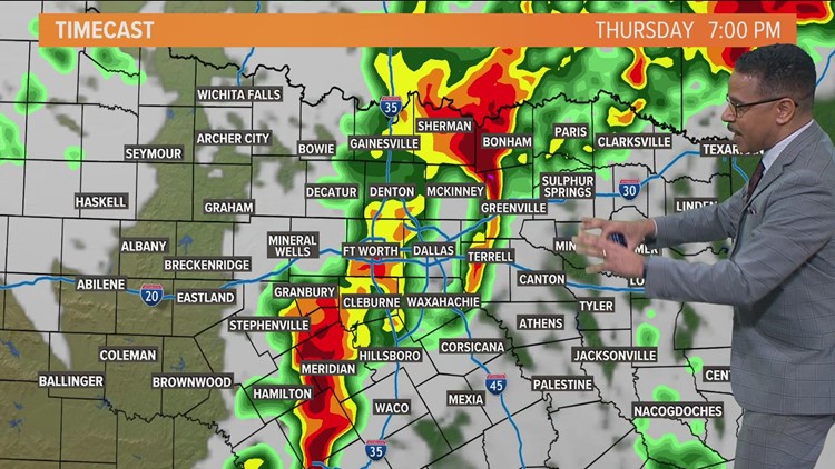
Better storm chances will be during the afternoon into evening as a cold front enters North Texas.
Storms will develop along that cold front likely somewhere west of the DFW area. Exactly where is still not completely certain, but likely between Abilene and Fort Worth.
Those storms will then form into a line and sweep across North Texas arriving in DFW anywhere from 4 p.m. to 7 p.m.
It is possible to see a few isolated strong to severe storms during the early afternoon time frame, before the main line of storms arrives.
Here’s an idea of the timeline:
The primary concern with that line of storms will be strong wind gusts (60-70mph) and large hail (quarter to golf ball size). With a line of storms, the tornado threat is certainly not zero, but it is lower than with individual supercell type storms. Within that line there could be a few brief spin-up tornadoes.
Storms will move east and out of North Texas through the late night hours, with the area looking storm-free by midnight.
Then comes the winds
Non-thunderstorm wind gusts overnight Thursday into Friday morning could be as high as 50 MPH. Winds will get better by late Friday morning and by the afternoon. This will bring much cooler air into the area for Friday.
Please stay weather aware Thursday as our entire team tracks the storms from development to departure.
Share this news on your Fb,Twitter and Whatsapp
Times News Network:Latest News Headlines
Times News Network||Health||New York||USA News||Technology||World News